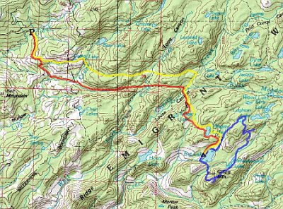
 My
first solo trip!My
first solo trip!
It looked for a while like it wasn't going to happen, but
after twice postponing it I finally pulled the trigger on Friday
evening. I had everything packed up in an hour and woke up
early Saturday morning for the drive up. I picked this part
of Emigrant mostly because it was close: from the time I woke
up to hitting the trail was only 4.5 hours! I also wanted
something off-trail, but not too hard to navigate.
My
first solo trip!My
first solo trip!
It looked for a while like it wasn't going to happen, but
after twice postponing it I finally pulled the trigger on Friday
evening. I had everything packed up in an hour and woke up
early Saturday morning for the drive up. I picked this part
of Emigrant mostly because it was close: from the time I woke
up to hitting the trail was only 4.5 hours! I also wanted
something off-trail, but not too hard to navigate.
|
||||||||||||||||
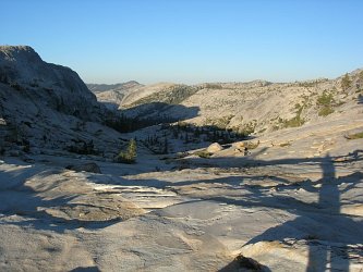
 The
strangest part of the trip was starting off. Nobody with
whom to coordinate packing, nobody to ask "Ready?"...just start
walking! From Crabtree,
the trail winds slowly up
and around a hill. With the new, lightweight equipment and
food
for only three days, my pack felt wonderfully light. From the
top
of the hill, I
took the right turn down into Pine
Valley. This trail is a
pack animal highway and had been ground into a thick layer of dust.
I looked like Pigpen trudging along, and by lunchtime my
calves
were a dark brown.
The
strangest part of the trip was starting off. Nobody with
whom to coordinate packing, nobody to ask "Ready?"...just start
walking! From Crabtree,
the trail winds slowly up
and around a hill. With the new, lightweight equipment and
food
for only three days, my pack felt wonderfully light. From the
top
of the hill, I
took the right turn down into Pine
Valley. This trail is a
pack animal highway and had been ground into a thick layer of dust.
I looked like Pigpen trudging along, and by lunchtime my
calves
were a dark brown.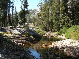 After
lunch I scrambled down the remaining 100' into the canyon, passed
through some nice camp sites along the creek, and started up the other
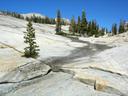
side. From this point on, my hike was off-trail. I
climbed south, up the shoulder of a creek bed that cut diagonally down
the side of the canyon. The creek bed was made of beautifully
red, blocky rocks, and must be quite a sight when wet.
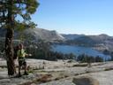
Emerging into the meadow at
the top, I skirted the hill to my right and climbed up to an overlook
from which I could get a view of Rosasco
Lake nestled in its valley.
From here I climbed down the ridge, across a broad valley,
and up the gentle rise to the shores of Pingree Lake.
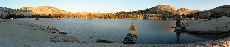
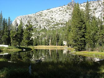
This
lake is gorgeous: full of islands and weird
peninsulas, with granite cliffs in the background. It looked
quite shallow, though, and not great for swimming.
After
lunch I scrambled down the remaining 100' into the canyon, passed
through some nice camp sites along the creek, and started up the other
side. From this point on, my hike was off-trail. I
climbed south, up the shoulder of a creek bed that cut diagonally down
the side of the canyon. The creek bed was made of beautifully
red, blocky rocks, and must be quite a sight when wet.
Emerging into the meadow at
the top, I skirted the hill to my right and climbed up to an overlook
from which I could get a view of Rosasco
Lake nestled in its valley.
From here I climbed down the ridge, across a broad valley,
and up the gentle rise to the shores of Pingree Lake.
This
lake is gorgeous: full of islands and weird
peninsulas, with granite cliffs in the background. It looked
quite shallow, though, and not great for swimming.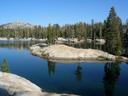 |
 |
|
||||||||||||
 The
plan for the day was to do a day hike and explore as many of the
central Emigrant lakes as I could get to. But first:
a view! I enjoyed a leisurely morning, then started off
towards my first goal: Gillett
Mountain. After
skirting the outlet of Big
Lake and its southern edge, I turned south
into a small valley. From there my first obstacle became
apparent: a pair of 20' vertical walls at the base of the Gillett Mountain.
With a little reconnaissance, I managed to find an
easy scramble over both of them, though, and was soon trudging up the
500' towards the west ridge of the mountain. From there
it was an easy walk to the saddle between the two peaks. I
decided to climb the south peak in order to get a view into Yosemite, so
from the saddle I turned right and climbed the remaining 150' to the peak.
The south peak of Gillett
Mountain has a nice, broad top
which quickly falls off to a cliff on the south. From the
peak there is a great view down into Cherry Creek Canyon
and Boundary
Lake
on its opposite side -- both of which I'd visited on previous
trips. To the northeast, in the direction I was hoping to
explore, I could see a beautiful sheer granite slope with what looked
like water running down it. Since running water was a rarity
on
this trip, I decided to try and make it over there later in the day.
The
plan for the day was to do a day hike and explore as many of the
central Emigrant lakes as I could get to. But first:
a view! I enjoyed a leisurely morning, then started off
towards my first goal: Gillett
Mountain. After
skirting the outlet of Big
Lake and its southern edge, I turned south
into a small valley. From there my first obstacle became
apparent: a pair of 20' vertical walls at the base of the Gillett Mountain.
With a little reconnaissance, I managed to find an
easy scramble over both of them, though, and was soon trudging up the
500' towards the west ridge of the mountain. From there
it was an easy walk to the saddle between the two peaks. I
decided to climb the south peak in order to get a view into Yosemite, so
from the saddle I turned right and climbed the remaining 150' to the peak.
The south peak of Gillett
Mountain has a nice, broad top
which quickly falls off to a cliff on the south. From the
peak there is a great view down into Cherry Creek Canyon
and Boundary
Lake
on its opposite side -- both of which I'd visited on previous
trips. To the northeast, in the direction I was hoping to
explore, I could see a beautiful sheer granite slope with what looked
like water running down it. Since running water was a rarity
on
this trip, I decided to try and make it over there later in the day. After
a nice rest on top, I climbed back down to the saddle and made my
way through some thick brush to the east ridge of the mountain.
I found some fairly fresh bear poop on the way, so I did most
of this traverse while singing, a stark contrast to the normal silence
of
hiking alone. From the top of the east ridge I descended
diagonally down towards Yellowhammer
Lake,
encountering some rough
terrain and brush, but nothing impassible. Eventually I
emerged
on the eastern shore of the lake and began scouting for a lunch spot.
Yellowhammer
Lake
is long, thin, and deep, hemmed in on both sides by steep rocks.
I found a small ledge just above the waterline and sat down
to
eat. This was a fabulous spot, completely isolated and quiet,
in
full sun. I spent an hour here, swimming, eating, and
reading,
and never heard another voice -- just bugs buzzing and fish jumping.
After
a nice rest on top, I climbed back down to the saddle and made my
way through some thick brush to the east ridge of the mountain.
I found some fairly fresh bear poop on the way, so I did most
of this traverse while singing, a stark contrast to the normal silence
of
hiking alone. From the top of the east ridge I descended
diagonally down towards Yellowhammer
Lake,
encountering some rough
terrain and brush, but nothing impassible. Eventually I
emerged
on the eastern shore of the lake and began scouting for a lunch spot.
Yellowhammer
Lake
is long, thin, and deep, hemmed in on both sides by steep rocks.
I found a small ledge just above the waterline and sat down
to
eat. This was a fabulous spot, completely isolated and quiet,
in
full sun. I spent an hour here, swimming, eating, and
reading,
and never heard another voice -- just bugs buzzing and fish jumping. |
 |
 After
half an hour of exploration and
photography, I continued up the canyon towards my supposed cascade.
When I reached it, however, I was disappointed: it
was
merely stains on the rock. I continued up the slope
to a
flat shelf about halfway up the ridge. There I was confronted with
another
obstacle: a 40' wall of granite. I traversed east
to a
viewpoint down on to Five
Acre Lake,
but could find no break in the wall. Next I tried west, and
eventually found what looked like a feasible path up the face.
It
was, but just barely. After pushing through some brush and
hauling myself up some tight crevices, I emerged on top of the cliff,
fairly well exhausted. The hill continued up gently from
here,
and after cresting the broad ridge I was able to easily walk to the
shores of Kole Lake.
This was a bucolic little lake, surrounded by forest and low
rocks. I sat there for a while, eating, reading, and
regaining my
strength.
After
half an hour of exploration and
photography, I continued up the canyon towards my supposed cascade.
When I reached it, however, I was disappointed: it
was
merely stains on the rock. I continued up the slope
to a
flat shelf about halfway up the ridge. There I was confronted with
another
obstacle: a 40' wall of granite. I traversed east
to a
viewpoint down on to Five
Acre Lake,
but could find no break in the wall. Next I tried west, and
eventually found what looked like a feasible path up the face.
It
was, but just barely. After pushing through some brush and
hauling myself up some tight crevices, I emerged on top of the cliff,
fairly well exhausted. The hill continued up gently from
here,
and after cresting the broad ridge I was able to easily walk to the
shores of Kole Lake.
This was a bucolic little lake, surrounded by forest and low
rocks. I sat there for a while, eating, reading, and
regaining my
strength.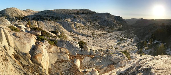
|
||||||||||||||||
 |
 |
 A
little ways above Piute
Lake I found a nice hill overlooking Cherry Creek where I
sat and had lunch. After eating, I continued down the trail
to Piute Meadow,
then up again on the other side. This was a brutal climb in
the
heat of the day, and I stopped for a while at the top to rest and pump
water from a lily-filled pond. From here the trail descended
again to Lily Creek,
the only flowing creek I found the entire trip. A more
manageable climb lead from there up to Camp Lake (no
camping), and then down again to the junction with the Pine Valley
trail.
A
little ways above Piute
Lake I found a nice hill overlooking Cherry Creek where I
sat and had lunch. After eating, I continued down the trail
to Piute Meadow,
then up again on the other side. This was a brutal climb in
the
heat of the day, and I stopped for a while at the top to rest and pump
water from a lily-filled pond. From here the trail descended
again to Lily Creek,
the only flowing creek I found the entire trip. A more
manageable climb lead from there up to Camp Lake (no
camping), and then down again to the junction with the Pine Valley
trail.  Retracing
my steps from the first day, I soon arrived
back
at the trailhead. A quick rinse of my Pigpen legs in the stream, a final
check-in with my SPOT, and I was back in the car, driving home.
A
mere 3.5 hours later (not including my traditional stop at the Tracy In-N-Out Burger)
I was home, in plenty of time to help with homework!
Retracing
my steps from the first day, I soon arrived
back
at the trailhead. A quick rinse of my Pigpen legs in the stream, a final
check-in with my SPOT, and I was back in the car, driving home.
A
mere 3.5 hours later (not including my traditional stop at the Tracy In-N-Out Burger)
I was home, in plenty of time to help with homework!