Hoover/Yosemite, July 2010
Back to other trips
 This being our
second attempt at this
route, I was planning on calling
this trip Return to Broketooth Mountain.
However, it turned
out to be more appropriately called the High and Low Trip
-- we
experienced a large range of elevation, weather, and mood.
And all our talk about the amount of snow and water last year was
pathetic compared to the obstacles put in our way this year.
This being our
second attempt at this
route, I was planning on calling
this trip Return to Broketooth Mountain.
However, it turned
out to be more appropriately called the High and Low Trip
-- we
experienced a large range of elevation, weather, and mood.
And all our talk about the amount of snow and water last year was
pathetic compared to the obstacles put in our way this year.
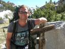
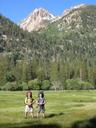
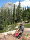
Sadly, Eric couldn’t join us, so it was just Alex
and I. A severe lack of goofiness was felt.
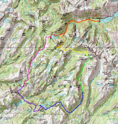
Day 0: Drive
Up
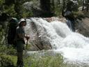
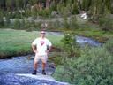
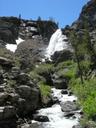 On
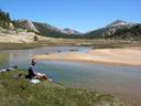
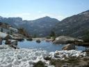
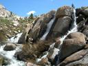
the way up I stopped off for a hike to Sardine Falls,
just a mile
off of US 108 near Sonora Pass. I then
continued on to
Bridgeport, where I spent the afternoon enjoying the
July 4th
festivities and exploring the Mono County Museum.
Alex arrived around 6 p.m. We had a nice
dinner at the Bridgeport Inn and then hung out at
the rodeo grounds as
the sun set. We skipped Travertine Hot Springs
for fear they
would be very crowded this weekend.
On
the way up I stopped off for a hike to Sardine Falls,
just a mile
off of US 108 near Sonora Pass. I then
continued on to
Bridgeport, where I spent the afternoon enjoying the
July 4th
festivities and exploring the Mono County Museum.
Alex arrived around 6 p.m. We had a nice
dinner at the Bridgeport Inn and then hung out at
the rodeo grounds as
the sun set. We skipped Travertine Hot Springs
for fear they
would be very crowded this weekend.
 Day 1: Mono
Village to Peeler Lake
Day 1: Mono
Village to Peeler Lake
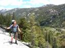
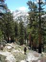
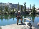
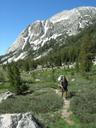
Our first day’s hike was much like our last attempt in 2006,
minus Eric and a mule. We carried our packs this time, and it
wasn’t too bad. I didn’t take many
pictures, though, so you can refer to the
last trip for some scenery.
At the first ford we had to remove our boots, which should’ve
told us something -- I can’t even count the number of times
we had to de-boot on this trip. In an attempt to avoid two
more crossings after Barney Lake, we detoured over
a small
shoulder. This did not work out well, and we ended up having
to de-boot anyway to cross a small but very speedy side
creek. Halfway across I slipped, caught myself on a rock, and
stood up again, still dry. Then I noticed one of my liner
socks had fallen out of my boot and was floating
downstream... I quickly reached out my hiking pole and
scooped it up! Possibly my proudest moment on the trip.
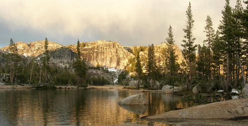
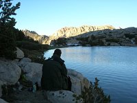
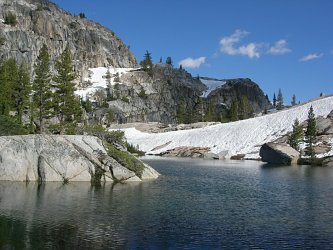
 Peeler
Lake
was just as magnificent as we remembered
it, but our
excellent campsite was under a foot of snow and meltwater so we found
something up on the rocks nearby instead. The lake water was
so cold it was painful after about 10 seconds. We only took a
brief
dip. By the time it got dark at 9pm, we were too tired for a
campfire and went straight to bed. This pattern repeated every
night, and this ended up being our first trip without a single campfire.
Peeler
Lake
was just as magnificent as we remembered
it, but our
excellent campsite was under a foot of snow and meltwater so we found
something up on the rocks nearby instead. The lake water was
so cold it was painful after about 10 seconds. We only took a
brief
dip. By the time it got dark at 9pm, we were too tired for a
campfire and went straight to bed. This pattern repeated every
night, and this ended up being our first trip without a single campfire.
Day 2: Peeler
Lake to Seavey Pass
This day started out like the last trip, too: a pleasant
meander down Kerrick Canyon. It was wet,
but not
flooded. Near the spot where Alex’s tooth had
fallen out last time, we stopped for lunch on the idyllic, grassy banks
of the ice cold, swiftly flowing Rancheria Creek.
The sun was
incredibly warm, though, so we swam and lounged for almost an hour.
After lunch: Terra Incognita! We continued down
Kerrick Canyon, through a fabulous little gorge
below Price Peak, and
then started up the hill towards our junction with the PCT
and Seavey
Pass. We soon encountered our first snow bank,
which quickly
turned into a series of snow fields. Seavey Pass
is not tall
from the north, but climbing up snow with a full pack is exhausting!
 Eventually,
we struggled up the last pitch and found the
first of
Seavey Pass’s many lakes. While
resting here, we
ran into a nice New Zealander who was a few months into his
hike of the entire PCT. We thought that
was kind of neat and
unusual, until we ran into the next through-hiker. And the
next. It turns out that in order to fit the entire PCT
into a
season you must follow a pretty strict schedule, which causes the
through-hikers to travel in a loose pack. We just happened to
hit our section of the PCT at the same time as the
pack. We
must’ve met a dozen over the next two days! It felt
crowded.
Eventually,
we struggled up the last pitch and found the
first of
Seavey Pass’s many lakes. While
resting here, we
ran into a nice New Zealander who was a few months into his
hike of the entire PCT. We thought that
was kind of neat and
unusual, until we ran into the next through-hiker. And the
next. It turns out that in order to fit the entire PCT
into a
season you must follow a pretty strict schedule, which causes the
through-hikers to travel in a loose pack. We just happened to
hit our section of the PCT at the same time as the
pack. We
must’ve met a dozen over the next two days! It felt
crowded.
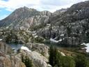
 In
any case, we’d planned to go cross-country to one of the
larger, more remote of the Seavey Pass lakes, but
our fatigue combined
with the tumbled topography of the pass made this seem
unwise. Instead, we found a lovely site at the far end of a
small, C-shaped lake. It had a great
layout and easy access
to remarkably warm water. Much swimming ensued, despite the
threatening profile of the Lake Monster underwater.
In
any case, we’d planned to go cross-country to one of the
larger, more remote of the Seavey Pass lakes, but
our fatigue combined
with the tumbled topography of the pass made this seem
unwise. Instead, we found a lovely site at the far end of a
small, C-shaped lake. It had a great
layout and easy access
to remarkably warm water. Much swimming ensued, despite the
threatening profile of the Lake Monster underwater.
Day 3: Seavey
Pass to Smedberg Lake
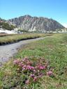
 This
day started off with a 1600’ descent, during which we saw a half-dozen
waterfalls. At the bottom of the hill was a swamp and a
half-mile spur trail to what is supposed to be a jewel of the
Sierra: Benson Lake.
But the
swamp was so teaming
with mosquitoes that we couldn’t bear the thought of
staying. We felt sorry for the other hikers we'd met who were
planning on camping there. After struggling over or through
three(!) difficult
creeks in the valley bottom, we climbed a hundred feet up the opposite
hill to some
wind-blown rocks and had lunch.
This
day started off with a 1600’ descent, during which we saw a half-dozen
waterfalls. At the bottom of the hill was a swamp and a
half-mile spur trail to what is supposed to be a jewel of the
Sierra: Benson Lake.
But the
swamp was so teaming
with mosquitoes that we couldn’t bear the thought of
staying. We felt sorry for the other hikers we'd met who were
planning on camping there. After struggling over or through
three(!) difficult
creeks in the valley bottom, we climbed a hundred feet up the opposite
hill to some
wind-blown rocks and had lunch.
Thus began our Ordeal Day. Not the traditional Death March,
this day was more varied and prolonged. After the
mosquito-infested swamp, it featured:
-
A
2000’ ascent --
in three miles!
- Three more stream crossings,
one of which filled my boot with water. Squelch squirch the rest of the day...
- A torrential rain storm
- ...which turned into a
hailstorm
- ...which at times produced hail
stones the size of gravel -- they hurt like hell when they hit your
head!
 We
hid out under a tree for a bit, then put on coats and
gloves and
kept going, continuing up under the dark sentinel of Volunteer
Peak. Eventually, we stumbled down to Smedberg
Lake
and began
looking for a suitable camp site. The ground was soaked, all
the sandy patches completely saturated. The sky was dark and
mosquitoes
swarmed around us. We settled on a slightly convex rock near
the lake’s outlet, climbed into the tent, and
grumbled. The sky cleared towards sunset, and we managed a
quick dinner. It was a beautiful spot, but I was not very happy
-- anxious and short of breath from a little altitude sickness.
We
hid out under a tree for a bit, then put on coats and
gloves and
kept going, continuing up under the dark sentinel of Volunteer
Peak. Eventually, we stumbled down to Smedberg
Lake
and began
looking for a suitable camp site. The ground was soaked, all
the sandy patches completely saturated. The sky was dark and
mosquitoes
swarmed around us. We settled on a slightly convex rock near
the lake’s outlet, climbed into the tent, and
grumbled. The sky cleared towards sunset, and we managed a
quick dinner. It was a beautiful spot, but I was not very happy
-- anxious and short of breath from a little altitude sickness.
Day 4:
Smedberg Lake to Matterhorn Canyon
The day broke clear and bright, and Smedberg Lakewas infinitely
more
inviting. The swimming was bad, but I explored the lake outlet
and took some nice pictures. We broke camp and started up the
short climb to
blissfully mosquito-free Benson Pass.
From there, the trail
descended next to Wilson Creek, a fabulous tumble
of rocks, grass, and
water. Once again we attempted to skirt two stream crossings
by going off-trail, but this time we were more successful -- except for
when Alex slipped and bruised up his arm.
We re-joined the trail, which eventually dropped us onto the floor of
Matterhorn Canyon. We followed the creek upstream to a wide crossing and had lunch while our feet dried. Immediately
after the crossing, our trail left the PCT, and we
didn’t see
another soul for a full day.
 We
attempted one more cross-country avoidance of stream crossings, and
this one was also successful, though Alex looked a little uneasy on the
steep slopes. We re-joined the trail just below Quarry
Peak
and set up camp in a small pine grove. It was a little early,
but we were tired and wanted to get the tent up before the
rain. The rain never came. We thought the spot
would be mosquito-free, but 20 minutes later we were proved
wrong. We spent a few hours enduring the very beautiful but
quite buggy canyon, wishing we'd kept hiking. The bugs never let up, and we had a cold
dinner in the tent rather than deal with them.
We
attempted one more cross-country avoidance of stream crossings, and
this one was also successful, though Alex looked a little uneasy on the
steep slopes. We re-joined the trail just below Quarry
Peak
and set up camp in a small pine grove. It was a little early,
but we were tired and wanted to get the tent up before the
rain. The rain never came. We thought the spot
would be mosquito-free, but 20 minutes later we were proved
wrong. We spent a few hours enduring the very beautiful but
quite buggy canyon, wishing we'd kept hiking. The bugs never let up, and we had a cold
dinner in the tent rather than deal with them.
Day 5:
Matterhorn Canyon to Burro Pass
We were so worried about mosquitoes the next morning that we skipped
breakfast and speed-packed so we could get hiking as soon as
possible. Guess what: no mosquitoes. It
was at this point that I started to doubt my backpacking skills.
 Seeing
our mistake, we stopped at a large rock on the banks of
Matterhorn Creek to eat something and enjoy a little bit of the morning. Alex,
attempting to wash
his hands, slipped and fell into the creek, immersing both
boots. It was at this point that we started to doubt
Alex’s boot traction and sense of balance.
Seeing
our mistake, we stopped at a large rock on the banks of
Matterhorn Creek to eat something and enjoy a little bit of the morning. Alex,
attempting to wash
his hands, slipped and fell into the creek, immersing both
boots. It was at this point that we started to doubt
Alex’s boot traction and sense of balance.
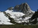
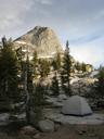
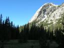
 After
drying out a bit, we continued up the canyon, eventually getting
our first glimpses of Sawtooth Ridge and Matterhorn
Peak.
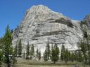
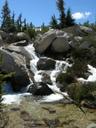
Then, under the massive granite shoulder of Whorl Mountain,
we found
the world’s most beautiful waterfall. It was
actually a whole series of cascades, each unique, each beautiful and
full of life, and all of them under the staggering point of Matterhorn
Peak. We ate lunch and spent a couple of hours just
sitting
there, in awe.
After
drying out a bit, we continued up the canyon, eventually getting
our first glimpses of Sawtooth Ridge and Matterhorn
Peak.
Then, under the massive granite shoulder of Whorl Mountain,
we found
the world’s most beautiful waterfall. It was
actually a whole series of cascades, each unique, each beautiful and
full of life, and all of them under the staggering point of Matterhorn
Peak. We ate lunch and spent a couple of hours just
sitting
there, in awe.
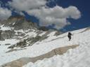
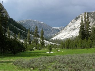
Finally, reluctantly, we decided to move on, ascending the final 800’ to
Burro Pass. Alex had a tough time with
this ascent and when
we reached the snow-covered summit he wanted to keep right on going
into camp rather than stop and enjoy the view.
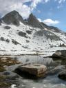
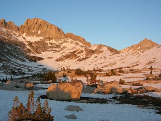
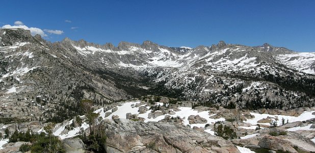
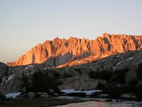
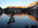
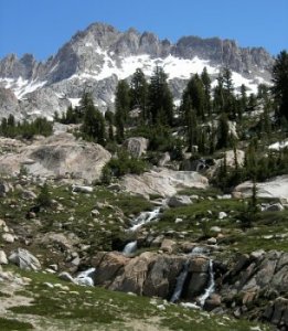
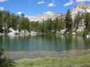
We slid quickly down a few hundred feet of snow, then made
our way across the crazy moonscape of snow to the unnamed lake just
below the Finger Peaks. This lake was one
of my primary goals for the whole trip because I was
sure it would have a great view of the Sawtooths.
I was not
disappointed. The view was fantastic: the entire Sawtooth
Ridge, Matterhorn Peak, and the Finger
Peaks surrounded us like the
jaws of a world-sized Lake Monster. We set up
camp on a great little outcropping near the mostly frozen lake and
spent the rest of the daylight hours just gazing in wonder.
There were no mosquitoes and no rain. This was one of the
best spots I’d ever found in ten years of these trips.
Alex, however, was not feeling well and began taking drugs for altitude
sickness.
Day 6: Burro
Pass to Snow Lake
We'd planned on spending two nights at Burro Pass and climbing Matterhorn Peak
in between, but the gully to the top looked impassible, still
covered in snow. Reluctantly, we packed up camp the next morning
and started down the
trail towards Slide Canyon. It was a
pleasant walk,
descending into a forest, and we successfully avoided two more stream
crossings with some easy cross-country. Sadly, the forest was
too thick to get a good view of The Slide, a giant,
prehistoric
rockfall that completely blocks the canyon lower down and shows
up as a treeless rectangle on the map.
Near the low point on the trail we ran into a Hoover Wilderness ranger
playing hookey for the day in Yosemite lands. She had just
come over Mule Pass and assured us it was
passable. This
turned out to be very fortunate for us, since her recent passage gave
us a nice set of footprints to backtrack when the trail disappeared
under the extensive snowfields.
Unfortunately, our luck ran out where she’d slid down a
60-degree slope of slush and ice -- no way we could make it up
that. We tried scrambling up a nearby rock outcropping, but
it was too difficult and ended in a cliff (and a cut knee). So I
stretched my topo-reading skills and figured out where the trail was
supposed to be. Even then we had to climb straight up a steep hill
of rocks and snow. By the time we reached the pass, we were
exhausted both physically and mentally. We had a long,
restful lunch, looking out over the Sawtooths, with
Eocene Peak in the
foreground and Crown Point behind us.
 At least, we thought, the hard part was behind us. Well,
kinda. After passing a small lake and its lovely tarns, the
descent from Mule Pass was a semi-controlled slide
down a giant
snowfield peppered with boulders. At the bottom, we finally
picked up the trail again -- but ended up walking the wrong direction
on it for a few minutes! Turned around again, we completed
the descent to Robinson Creek, where our trail
turned left and climbed
500’ to Snow Lake.
At least, we thought, the hard part was behind us. Well,
kinda. After passing a small lake and its lovely tarns, the
descent from Mule Pass was a semi-controlled slide
down a giant
snowfield peppered with boulders. At the bottom, we finally
picked up the trail again -- but ended up walking the wrong direction
on it for a few minutes! Turned around again, we completed
the descent to Robinson Creek, where our trail
turned left and climbed
500’ to Snow Lake.
The climb was not bad, but the lake was uninviting. Lots of
snow, mosquitoes, poor camping, no real views -- it was very
discouraging after such a hard day, especially so because our updated plan was to stay here two nights and do a day hike
to Crown Point on Day 7. Alex was still
feeling ill, too --
he’d fallen a couple more times today -- and wasn’t
sure he’d feel safe climbing the peak. Given all of
that, we decided to skip the day hike and exit the wilderness a day
early
After setting up camp, we strolled over to Rock Island Pass
and around
Snow Lake before settling down to our last dinner of
the trip.
Day 7: Snow
Lake to Mono Village
 We left Snow Lake early so we might have a chance
of seeing our kids
before bedtime. On the way back to the Peeler Lake
trail, we
passed Crown Lake and the Robinson Lakes,
all of which were lovely yet
somewhat trampled.
We left Snow Lake early so we might have a chance
of seeing our kids
before bedtime. On the way back to the Peeler Lake
trail, we
passed Crown Lake and the Robinson Lakes,
all of which were lovely yet
somewhat trampled.
After lunch at the junction, we retraced our path down to Barney
Lake
and then on down to Mono Village. On the
way, I had a new experience: I was attacked
by a mourning dove. It was quite startling, really:
it ran in circles, beating its wings loudly, and then charged my
boots. I have to admit, I backed up. The dove was
soon satisfied, though, and took off into the bushes, where I saw a
brood of mini-doves squeaking and running away.
Back in Mono Village, we threw our gear in the
cars, changed our
clothes, and drove into Bridgeport to call our
wives with the good
news of our early exit. Alex took off, but I had an early dinner at The
Barn --
best cheeseburger and fries EVAR!

Last Modified: